


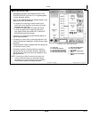

Levee
Continuedon next page JS56696,00009EC1916MAY111/2
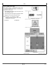
Mark Path (Drive Dial)
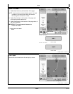
1. Set desired elevation drop between levees in the
ELEVATION DROP input box (D). A keypad appears
to enter elevation amount.
2. Drive to the starting location for marking levees or the
high point to SET ELEVATION.
•
If operator is continuing to mark levees from a
previously known elevation, such as a prior levee,
proceed to the next step.
•
If operator is beginning a new field and needs
to mark the high point or beginning elevation
from which levees are marked off of, select SET
ELEVATION button (B) to begin.
3. Increase (C) or decrease (E) ELEVATION DROP to
adjust target elevation.
4. Proceed up or down slope to the target elevation. Be
careful driving down headlands. Avoid driving on large
obstacles.
5. Target elevation is been reached when the vertical dial
is centered on the 0 (zero).
6. Proceed to mark the levee location by traversing
through the field at a constant elevation. Keep the
dial at the zero position as much as possible for that
particular levee.
NOTE: If returning to field to mark more levees and
using a quickstart base (no permanent base),
set receiver on previous levee and set elevation
button before setting next target elevation.
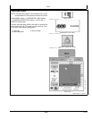
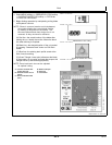
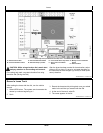
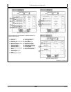
PC13743—UN—16MAY11
GreenStar 3 Pro—Water Management
A—Levee tab
B—Set Elevation button
C—Increase Elevation button
D—Elevation Drop input box
E—Decrease Elevation button
F—AutoTrac Enable button
G—Levee Track Name
dropdown
H—New Levee Track Name
button
I— Modify Levee Track Name
button
454
061611
PN=47