


Section 1. Preparation and Siting
1-8
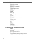
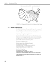
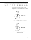
Subtract declination from 360° Add declination to 0°
22 E
18 E
16 E
14 E
12 E
10 E
8 E
6 E
4 E
2 E
0
2 W
4 W
6 W
8 W
10 W
14 W
12 W
16 W
18 W
20 W
20 E
FIGURE 1.4-1. Magnetic Declination for the Contiguous United States
1.4.1 NSSDC CGM Service
The NSSDC CGM (Corrected Geomagnetic) Service provides an easy way of
determining magnetic declination of a specific site. Since magnetic declination
fluctuates with time, it should be determined each time the wind vane
orientation is adjusted. It can be accessed on the world wide web at
http://nssdc.gsfc.nasa.gov/space/cgm/cgm.html
If you know the latitude and longitude of your site, fill out Form 1as shown
below for an accurate magnetic declination. If you do not know the latitude
and longitude of your site, fill out Form 2 for estimate of magnetic declination.
Note that longitude is expressed in 0 to 360 degrees east of the Greenwich
prime meridian, and that north latitudes are positive.
Query Form 1: Latitude/Longitude
Latitude/Longitude below specified in: Geographic
Year (from 1945 to 2000): 1998
Altitude above Earth's surface (km) [from 0. to 40000.]: 0
Latitude (degrees) [from -90.00 to 90.00]: 42.03
Longitude (degrees) [from 0.00 to 360.00]: 248.15
Query Form 2: Image Map
Year (from 1945 to 2000): 1998
Altitude above Earth's surface (km) [0. - 40000.]: 0
Click on map to specify location and submit: (select area on map provided)
A table containing similar information to the following will be returned after
submitting Forms 1 or 2.