


PRIMUS
R
660 Digital Weather Radar System
A28–1146–111
REV 2
Radar Facts
5-38
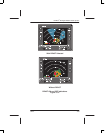
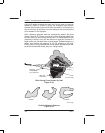
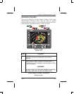
Using a tilt setting that has the radar look into the area of maximum
reflectivity (5000 to 20,000 ft) gives the strongest radar picture.
However the tilt setting must not be left at this setting. Periodically, the
pilot should look up and down from this setting to see the total picture
of the weather in the flightpath.
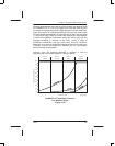
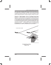
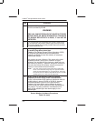
Often, hailstorms generate weak but characteristic patterns like those
shown in figure 5–35. Fingers or hooks of cyclonic winds that radiate from
the main body of a storm usually contain hail. A U shaped pattern is also
(frequently) a column of dry hail that returns no signal but is buried in a
larger area of rain that does return a strong signal. Scalloped edges on a
pattern also indicate the presence of dry hail bordering a rain area.
Finally, weak or fuzzy protuberances are not always associated with hail,
but should be watched closely; they can change rapidly.
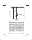
AD–12059–R1@
BEAM IN
DOWNWARD
TILT POSITION
WET HAIL
AND RAIN
DRY HAIL
Rain Coming From Unseen Dry Hail
Figure 5–34
U–SHAPEHOOKFINGER
AD–35713@
Familiar Hailstorm Patterns
Figure 5–35