


EQUATORIAL (POLAR) ALIGNMENT
APPENDIX D:
Polar Alignment
In Polar Alignment, the telescope is oriented so that
the horizontal and vertical axes of the telescope are
lined up with the celestial coordinate system.
In order to Polar align your telescope, it is essential
to have an understanding of how and where to locate
celestial objects as they move across the sky. This
section provides a basic introduction to the terminology
of Polar-aligned astronomy, and includes instructions
for fi nding the celestial pole and for fi nding objects in
the night sky using declination and right ascension.
Celestial Coordinates
A celestial coordinate system was created that maps
an imaginary sphere surrounding the Earth upon which
all stars appear to be placed. This mapping system is
similar to the system of latitude and longitude on Earth
surface maps.
In mapping the surface of the Earth, lines of longitude
are drawn between the North and South Poles and
lines of latitude are drawn in an East-West direction,
parallel to the Earth’s equator. Similarly, imaginary
lines have been drawn to form a latitude and longitude
grid for the celestial sphere. These lines are known as
right ascension and declination.
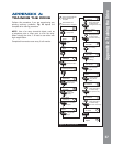
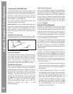
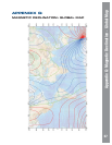
The celestial map also contains two poles and an
equator just like a map of the Earth. The poles of this
coordinate system are defi ned as those two points
where the Earth’s north and south poles (i.e., the
Earth’s axis), if extended to infi nity, would cross the
celestial sphere. Thus, the North Celestial Pole (Fig.
46, 1) is that point in the sky where an extension of the
North Pole intersects the celestial sphere. The North
Star, Polaris is located very near the North Celestial
Pole (Fig. 46, 1). The celestial equator (Fig. 46, 2) is
a projection of the Earth’s equator onto the celestial
sphere.
So just as an object’s position on the Earth’s surface
can be located by its latitude and longitude, celestial
objects may also be located using right ascension and
declination. For example, you could locate Los Angeles,
California, by its latitude (+34°) and longitude (118°).
Similarly, you could locate the Ring Nebula (M57) by its
right ascension (18hr) and its declination (+33°).
• Right Ascension (RA): This celestial version
of longitude is measured in units of hours (hr),
minutes (min), and seconds (sec) on a 24-hour
“clock” (similar to how Earth’s time zones are
determined by longitude lines). The “zero” line was
arbitrarily chosen to pass through the constellation
Pegasus — a sort of cosmic Greenwich meridian.
RA coordinates range from 0hr 0min 0sec to 23hr
59min 59sec. There are 24 primary lines of RA,
located at 15-degree intervals along the celestial
equator. Objects located further and further East of
the zero RA grid line (0hr 0min 0sec) carry higher
RA coordinates.
• Declination (DEC): This celestial version of
latitude is measured in degrees, arc-minutes, and
arc-seconds (e.g., 15° 27’ 33”). DEC locations north
of the celestial equator are indicated with a plus (+)
sign (e.g., the DEC of the North celestial pole is
+90°). DEC locations south of the celestial equator
are indicated with a minus (–) sign (e.g., the DEC
of the South celestial pole is –90°). Any point on
the celestial equator (such as the constellations
of Orion, Virgo and Aquarius) is said to have a
declination of zero, shown as 0° 0’ 0
14
15
16
17
18
19
20
21
22
23
0
1
12
11
10
9
8
7
5
6
4
3
2
13
Earthís
Rotation
0 Dec.
South
Celestial
Pole
Right Ascension
Star
Celestial
Equator
-90 Dec.
+90 Dec.
North
Celestial
Pole
(Vicinity
of Polaris)
D
e
c
l
i
n
a
t
i
o
n
1
2
Figure 46: Celestial Sphere
61
Appendix D: Equatorial ( Polar Alignment)