


page 39
APPENDIX B: Terrestrial Viewing, Celestial Movement,
and Polar Alignment
Terrestrial Viewing
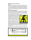
The 4504 is an excellent, high-resolution terrestrial (land) telescope. Viewing terrestrial
objects requires looking along the Earth's surface through heat waves. These heat
waves often cause degradation of image quality. Low power eyepieces, like the H 25mm
eyepiece, magnify these heat waves less than higher power eyepieces. Therefore, low
power eyepieces provide a steadier, higher quality image. If the image is fuzzy or ill-
defined, reduce to a low-power, where the heat waves do not have such an effect on
image quality. Observing in early morning hours, before the ground has built up internal
heat, produces better viewing conditions than during late-afternoon hours.
Astronomical Observing
Used as an astronomical instrument, your telescope has many optical and electro-
mechanical capabilities. It is in astronomical applications where the high level of opti-
cal performance is readily visible. The range of observable astronomical objects is,
with minor qualification, limited only by the observer’s motivation.
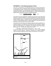
Polar Alignment
Lunar or planetary photography requires that the telescope be Polar aligned. In Polar
Alignment, the telescope is oriented so that the horizontal and vertical axes of the tele-
scope are lined up with the celestial coordinate system.
In order to understand Polar Alignment, it is essential to have an understanding of how
and where to locate celestial objects as they move across the sky. This section pro-
vides a basic introduction to the terminology of Polar-aligned astronomy, and includes
instructions for finding the celestial pole and for finding objects in the night sky using
Declination and Right Ascension.
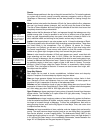
Understanding Celestial Movements and Coordinates
Understanding where to locate celestial objects and how those objects move across
the sky is fundamental to enjoying the hobby of astronomy. Most amateur astronomers
adopt the simple practice of “star-hopping” to locate celestial objects by using star
charts or astronomical software which identify bright stars and star patterns (constel-
lations) that serve as “road maps” and “landmarks” in the sky. These visual reference
points guide amateur astronomers in their search for astronomical objects.
Understanding How Astronomical Objects Move
Due to the Earth’s rotation, celestial bodies appear to move from East to West in a
curved path through the sky. The path they follow is known as their line of Right
Ascension (R.A.). The angle of the path that they follow is known as their line of
Declination (Dec). The system of R.A. and Dec is analogous to the Earth-based coor-
dinate system of latitude and longitude. Like Earth, imaginary lines have been drawn
on the celestial sphere to form a coordinate grid. Celestial object positions on the
Earth's surface are specified by their latitude and longitude.
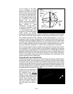
Understanding Celestial Coordinates
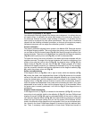
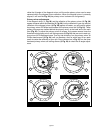
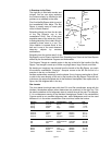
Celestial objects are mapped according to the R.A. and Dec coordinate system on the
“celestial sphere” (Fig. 31), the imaginary sphere on which all stars appear to be
placed. The Poles of the celestial coordinate system are defined as those two points
where the Earth's rotational axis, if extended to infinity, North and South, intersect the
celestial sphere. Thus, the North Celestial Pole is that point in the sky where an exten-
sion of the Earth's axis through the North Pole intersects the celestial sphere. In fact,
this point in the sky is located near the North Star, or Polaris.