


5-3
190-01122-03 Rev. A
GDL 88 ADS-B Transceiver Pilot’s Guide
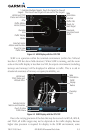
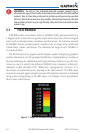
NOTE: FIS-B NEXRAD does not differentiate between frozen and liquid
precipitation. The FIS-B NEXRAD intensity colors (as shown below) may
differ from the intensity colors from other providers.
5.1.1 NEXRAD Abnormalities
TherearepossibleabnormalitiesregardingdisplayedNEXRADimages.Some,
but not all, causes of abnormal displayed information include:
•GroundClutter
•Strobesandspuriousradardata
•Sunstrobes,whentheradarantenna points directly at the sun
•Militaryaircraftdeploymetallicdustwhichcancausealterationsinradar
scans
•Interferencefrombuildingsormountains, which may cause shadows
•Scheduledmaintenancemayputaradaroff-line
5.1.2 NEXRAD Limitations
CertainlimitationsexistregardingtheNEXRADradardisplays.Some,butnot
all, are listed for the user’s awareness:
•NEXRAD base reectivity does not provide sufficient information to
determine cloud layers or precipitation characteristics (hail vs. rain, etc).
•NEXRAD basereectivityis sampledat theminimum antennaelevation
angle.AnindividualNEXRADsitecannotdepicthighaltitudestormsat
close ranges, and has no information about storms directly over the site.
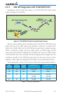
•The resolution of displayed Regional NEXRAD data is approximately
twokilometersandtheresolutionofdisplayedCONUSNEXRADdatais
approximately10kilometers.Therefore,whenzoomedinonthedisplay,
eachsquareblockistwokilometers(1.08NM)or10kilometers(5.4NM)
onaside.Theintensitylevelreectedbythesquarewillbethehighestlevel
sampled within the area covered by each block.