


4-2
GDL 88 ADS-B Transceiver Pilot’s Guide
190-01122-03 Rev. A
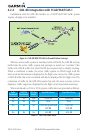
4.2 Traffic
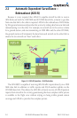
The GDL 88 may receive traffic from several sources including external sources
(ADS-B,ADS-R,andTIS-B)andonboardsources(TAS/TCAS) and creates a single,
fused traffic picture to provide to the flight crew. Using relative altitude, relative
bearing, range, directionality, ground track, and other identifying information
(ICAOaddress,ightID,callsign,tailnumber),theGDL88determineswhen
tracks from multiple sources represent a single traffic target, selects the most
accurate position source for the target, and sends the data to the display.
NOTE: The GDL 88 will observe all ADS-B participants within range. However,
due to the nature of TIS-B’s service volumes and the incomplete equipage/
adoption of ADS-B Out equipment, NOT ALL TRAFFIC WILL BE OBSERVED
by the GDL 88. The flight crew must rely on “see and avoid” procedures to
detect and avoid traffic. In addition, when operating on the edges of ATC
radar coverage or when using an interfaced active traffic system and TAS/
TCAS targets are intermittent, it is possible that a single target aircraft may be
briefly or periodically depicted as two grouped targets in the same location.
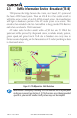
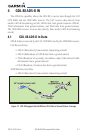
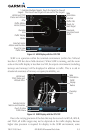
4.2.1 Traffic Applications – SURF, AIRB, etc
WhentheGDL88isinterfacedtoaGTN6XX,GTN7XX,orothercompatible
units, a traffic display is available for the flight crew’s situational awareness and to
enhancethevisualacquisitionofsurroundingtrafc.TheGNS400W/500Wunits
donotsupportallapplications,includingSURF.
The exact location of the ownship as shown by the ownship symbol on the
movingmapvariesbythedisplaydevice.ForGTNunits,thetipoftheownship
icon,orwherethedotis,identiestheexactlocation.ForGNSunits,theexact
location of the ownship is the center of the ownship icon where the wings cross
the fuselage.
This display is capable of running in two “modes:” Airborne Situational
Awareness(AIRB)andSurfaceSituationAwareness(SURF).
AIRBisinoperationintheenrouteenvironment,outsideofveNMfromand
1,500 feet above the nearest airport.