


4-6
GDL 88 ADS-B Transceiver Pilot’s Guide
190-01122-03 Rev. A
When a GDL 88 and TAS/TCAS system are integrated, the GDL 88 controls the
mode of the TAS/TCAS system using the air/ground logic in the GDL 88, as well
as from the mode controls available on the interfaced display.
4.2.3 No-Heading Source Traffic Information
When a GDL 88 and TAS/TCAS are integrated in an airplane without a heading
source, they are subject to certain limitations:
•Whileontheground,displayofTCAStrafcandADS-Btrafcaremutually
exclusive.
•TCAS (heading referenced trafc) and ADS-B trafc are allowed to be
displayed on the traffic page concurrently in a Track Up orientation while
airborne, but bearing of the TCAS targets relative to ADS-B targets will slewed
by the crab angle of the aircraft.
•Trafcisnotdisplayedonthemovingmapwithgroundfeaturesdepicted.
Traffic will always be available for display on the traffic page.
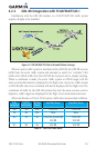
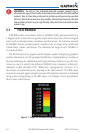
4.2.4 Conflict Situational Awareness (CSA)
Conflict Situational Awareness is an alerting algorithm that provides TCAS-
like Trafc Alerts on ADS-B, ADS-R, and TIS-B targets to enhance situational
awareness.
The GDL 88 issues an aural alert when a Conflict Situational Awareness (CSA)
alertisdisplayed:“Trafc-<X>O’Clock,<Y>,<Z>”spokenonce,(where<X>isthe
clockpositionoftheintruder,”,<Y>istherelativeposition(Above,Below),and
<Z>istherangeinnauticalmiles).
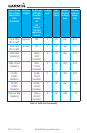
AsinsomeTCASITAimplementations,altitudeaboveterrainisusedtoadjust
thesensitivityoftheCSAalgorithmtominimizenuisancealerts.RadarAltitude
(if available), Height Above Terrain(asprovidedbyaGNSorGTNnavigatorwith
a terrain database), and Geodetic Altitude are used to adjust the sensitivity of the
CSA algorithm.
RadarAltitude(ifavailable),HeightAboveTerrain(ifavailable),andGeodetic
Altitude are used to adjust the sensitivity of the CSA algorithm, in accordance with
the following table: