


Celestial Coordinates
It is helpful to understand how to locate celestial
objects as they move across the sky.
A celestial coordinate system was created that
maps an imaginary sphere surrounding the Earth
upon which all stars appear to be placed. This
mapping system is similar to the system of latitude
and longitude on Earth surface maps.
In mapping the surface of the Earth, lines of
longitude are drawn between the North and South
Poles, and lines of latitude are drawn in an East-
West direction, parallel to the Earth’s equator.
Similarly, imaginary lines have been drawn to form
a latitude and longitude grid on the celestial
sphere. These lines are known as Right
Ascension and Declination.
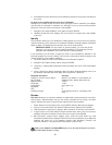
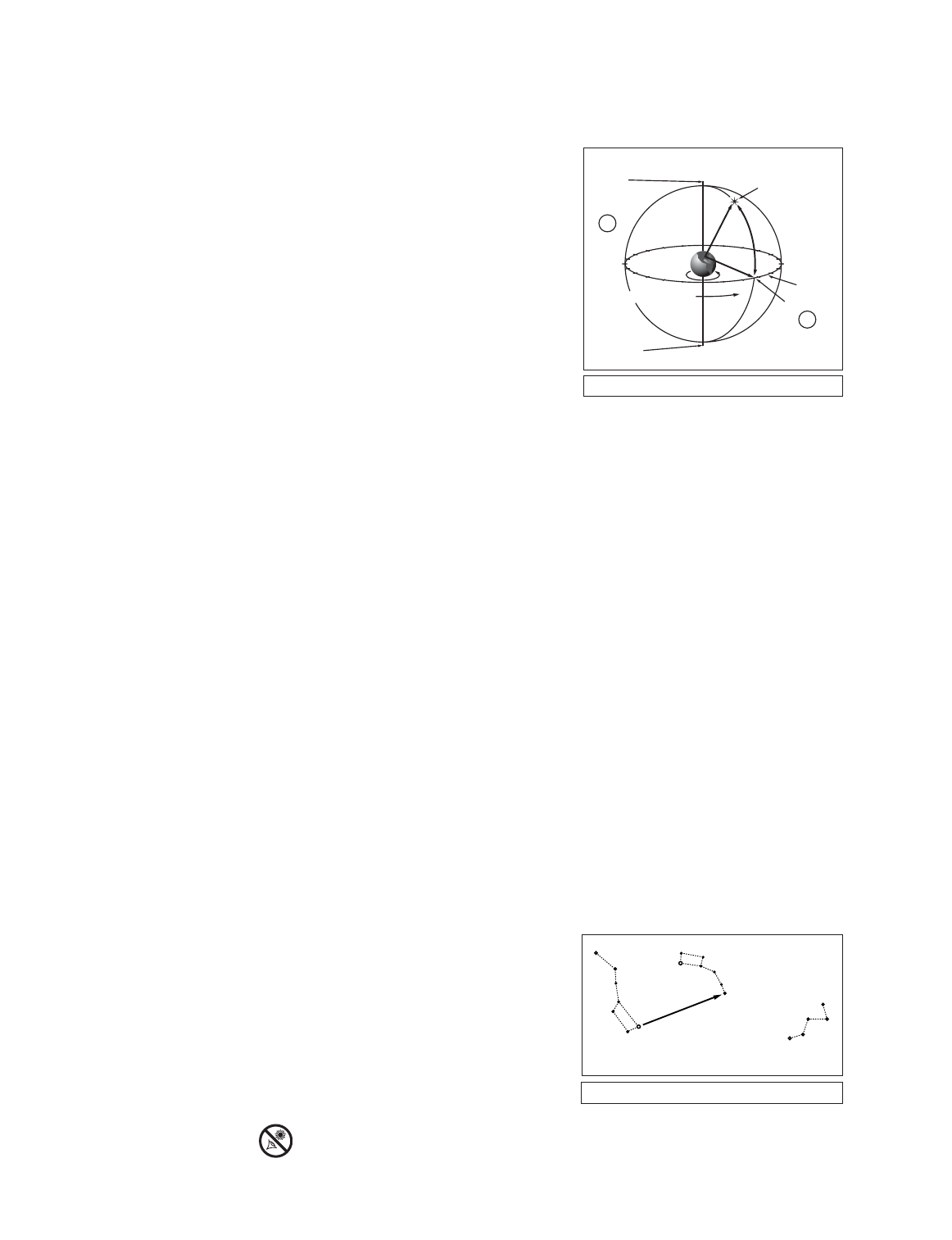
The celestial map also contains two poles and an equator just like a map of the Earth. The
poles of this coordinate system are defined as those two points where the Earth’s north and
south poles (
i.e.,
the Earth's axis), if extended to infinity, would cross the celestial sphere.Thus,
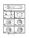
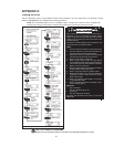
the North Celestial Pole (1, Fig. 30) is that point in the sky where an extension of the North Pole
intersects the celestial sphere.This point in the sky is located very near the North Star, Polaris.
The celestial equator (2, Fig. 30) is a projection of the Earth’s equator onto the celestial sphere.
So just as an object's position on the Earth’s surface can be located by its latitude and
longitude, celestial objects may also be located using Right Ascension and Declination. For
example, you could locate Los Angeles, California, by its latitude (+34°) and longitude (118°).
Similarly, you could locate the constellation Ursa Major (the Big Dipper) by its Right Ascension
(11hr) and its Declination (+50°).
• Right Ascension (R.A.): This celestial version of longitude is measured in units of hours (hr),
minutes (min) and seconds (sec) on a 24-hour "clock" (similar to how Earth's time zones are
determined by longitude lines). The "zero" line was arbitrarily chosen to pass through the
constellation Pegasus — a sort of cosmic Greenwich meridian. R.A. coordinates range from
0hr 0min 0sec to 23hr 59min 59sec.There are 24 primary lines of R.A., located at 15-degree
intervals along the celestial equator. Objects located further and further East of the zero R.A.
grid line (0hr 0min 0sec) carry higher R.A. coordinates.
• Declination (Altitude): This celestial version of latitude is measured in degrees, minutes,
and seconds (
e.g.,
15° 27' 33"). Dec.locations north of the celestial equator are indicated with
a plus (+) sign (
e.g.,
the Dec. of the North celestial pole is +90°). Dec. locations south of the
celestial equator are indicated with a minus (–) sign (
e.g.
, the Dec. of the South celestial pole
is –90°). Any point on the celestial equator (such as the the constellations of Orion, Virgo, and
Aquarius) is
said to have a Declination of zero, shown as 0° 0' 0."
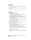
Locating the Celestial Pole
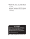
To get basic bearings at an observing location, take note of where the Sun rises (East) and sets
(West) each day. After the site is dark, face North by pointing your left shoulder toward where
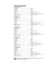
the Sun set.To precisely point at the pole, find the North Star (Polaris) by using the Big Dipper
as a guide (Fig. 31
).
IMPORTANT NOTE: For almost all
astronomical observing requirements,
approximate settings are acceptable. Do
not allow undue attention to precise
alignment of the telescope to interfere with
your basic enjoyment of the instrument.
14
15
16
17
18
19
20
21
22
23
0
1
12
11
10
9
8
7
5
6
4
3
2
13
Earth’s
Rotation
0 Dec.
South
Celestial
Pole
Right Ascension
Star
Celestial
Equator
-90 Dec.
+90 Dec.
North
Celestial
Pole
(Vicinity
of Polaris)
D
e
c
l
i
n
a
t
i
o
1
2
Fig. 30: Celestial Sphere.
APPENDIX A
Polaris
Little Dipper
Big Dipper
Cassiopeia
Fig. 31: Locating Polaris.
38
Looking at or near the Sun will cause irreversible damage to your eye. Do not point this telescope at or near the Sun.
Do not look through the telescope as it is moving.