


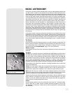


21
Celestial Coordinates
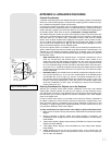
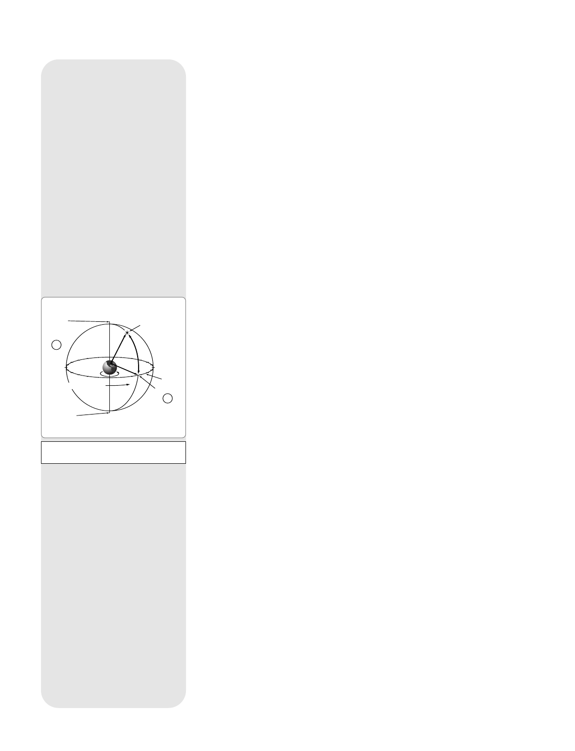
A celestial coordinate system was created that maps an imaginary sphere surrounding the
Earth upon which all stars appear to be placed. This mapping system is similar to the sys-
tem of latitude and longitude on Earth surface maps.
In mapping the surface of the Earth, lines of longitude are drawn between the North and
South Poles and lines of latitude are drawn in an East-West direction, parallel to the Earth’s
equator. Similarly, imaginary lines have been drawn to form a latitude and longitude grid for
the celestial sphere. These lines are known as Declination and Right Ascension.
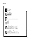
The celestial map also contains two poles and an equator just like a map of the Earth. The
poles of this coordinate system are defined as those two points where the Earth’s North
and South poles (
i.e.,
the Earth's axis), if extended to infinity, would cross the celestial
sphere. Thus, the North Celestial Pole (1, Fig. 17) is that point in the sky where an exten-
sion of the North Pole intersects the celestial sphere. The North Star, Polaris, is located
very near the North Celestial Pole (1, Fig. 17). The celestial equator (2, Fig. 17) is a pro-
jection of the Earth’s equator onto the celestial sphere.
So just as an object's position on the Earth’s surface can be located by its latitude and lon-
gitude, celestial objects may also be located using Right Ascension and Declination.
For
example
: You could locate Los Angeles, California, by its latitude (+34°) and longitude
(118°). Similarly, you could locate the Ring Nebula (M57) by its Right Ascension (18hr) and
its Declination (+33°).
• Right Ascension (R.A.): This celestial version of longitude is measured in units of
hours (hr), minutes (min) and seconds (sec) on a 24-hour "clock" (similar to how
Earth's time zones are determined by longitude lines). The "zero" line was arbitrarily
chosen to pass through the constellation Pegasus, a sort of cosmic Greenwich merid-
ian. R.A. coordinates range from 0hr 0min 0sec to 23hr 59min 59sec.There are 24 pri-
mary lines of R.A., located at 15-degree intervals along the celestial equator. Objects
located further and further East of the zero R.A. grid line (0hr 0min 0sec) carry high-
er R.A. coordinates.
• Declination (Dec.): This celestial version of latitude is measured in degrees, arc-min-
utes, and arc-seconds (
e.g.,
15° 27' 33"). Dec. locations North of the celestial equator
are indicated with a plus (+) sign (
e.g.,
the Dec. of the North celestial pole is +90°).
Dec. locations South of the celestial equator are indicated with a minus (–) sign (
e.g.
,
the Dec. of the South celestial pole is –90°). Any point on the celestial equator (such
as the the constellations of Orion, Virgo, and Aquarius) is
said to have a Declination
of zero, shown as 0° 0' 0."
Entering Coordinates for Objects not in the Database
Although your computer control panel contains a database of more than 1400 celestial
objects (stars, nebulae, planets, etc.) that you can observe, you may eventually want to
view objects that are not part of the database. The computer control panel provides a fea-
ture that allows you to enter an object's R.A and Dec. coordinates in the "User: Objects"
option of the Object menu.
In order to use this menu option, you first need to look up the R.A and Dec. coordinates of
the object or objects you wish to observe. Check your local library, computer store, book-
store, CD Roms, Internet, or magazines (such as
Sky & Telescope
or
Astronomy),
to find
coordinates of celestial objects. The objects/coordinates you enter become part of your
own permanent database, called "User Objects."
To enter coordinates of an object into the "User: Objects" option of the Object menu:
1. Make sure the computer control panel has been initialized and the telescope has been
aligned.
2. After the telescope is aligned, "Select Item: Object" displays. (If necessary, use
UP/DOWN to scroll through the menus, as previously described, to find this option.)
Press ENTER.
3. "Object: Solar System" displays. Keep pressing UP/DOWN until "Object: User Object"
displays and press ENTER.
4. "User Object: Select" displays. Press UP/DOWN until "User Object: Add" displays.
Press ENTER.
5. "Name" displays on the top line and a blinking cursor on the second line. Use
UP/DOWN and ENTER, as previously described, to enter the name of the object you
wish to add to the database.
14
15
16
17
18
19
20
21
22
23
0
1
12
11
10
9
8
7
5
6
4
3
2
13
Earth’s
Rotation
0 Dec.
South
Celestial
Pole
Right Ascension
Star
Celestial
Equator
-90 Dec.
+90 Dec.
North
Celestial
Pole
(Vicinity
of Polaris)
D
e
c
l
i
n
a
t
i
o
n
1
2
Fig. 17: Celestial Sphere.
APPENDIX A: ADVANCED FEATURES