


- 52 -
Looking at or near the Sun will cause irreversible damage to your eye. Do not point this telescope
at or near the Sun. Do not look through the telescope as it is moving.
Equatorial Alignment
In equatorial (or "polar") Alignment, the telescope is oriented so that the horizontal
and vertical axes of the telescope are lined up with the celestial coordinate system.
In order to equatorial align your telescope, it is essential to have an understanding of
how and where to locate celestial objects as they move across the sky. This section
provides a basic introduction to the terminology of equatorial-aligned astronomy, and
includes instructions for finding the celestial pole and for finding objects in the night
sky using Declination and Right Ascension.
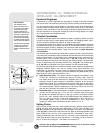
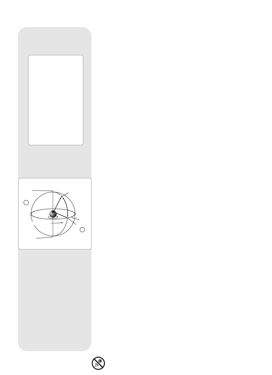
Celestial Coordinates
A celestial coordinate system was created that maps an imaginary sphere surround-
ing the Earth upon which all stars appear to be placed. This mapping system is simi-
lar to the system of latitude and longitude on Earth surface maps.
In mapping the surface of the Earth, lines of longitude are drawn between the North
and South Poles and lines of latitude are drawn in an East-West direction, parallel to
the Earth’s equator. Similarly, imaginary lines have been drawn to form a latitude and
longitude grid for the celestial sphere. These lines are known as Right Ascension
and Declination.
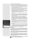
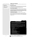
The celestial map also contains two poles and an equator just like a map of the Earth.
The poles of this coordinate system are defined as those two points where the Earth’s
North and South poles (
i.e.,
the Earth's axis), if extended to infinity, would cross the
celestial sphere. Thus, the North Celestial Pole (1, Fig. 38) is that point in the sky
where an extension of the North Pole intersects the celestial sphere. The North Star,
Polaris, is located very near the North Celestial Pole (1, Fig. 38). The celestial equa-
tor (2, Fig. 38) is a projection of the Earth’s equator onto the celestial sphere.
So just as an object's position on the Earth’s surface can be located by its latitude and
longitude, celestial objects may also be located using Right Ascension and
Declination.
For example
: You could locate Los Angeles, California, by its latitude
(+34°) and longitude (118°). Similarly, you could locate the Ring Nebula (M57) by its
Right Ascension (18hr) and its Declination (+33°).
a Right Ascension (R.A.): This celestial version of longitude is measured in units
of hours (hr), minutes (min), and seconds (sec) on a 24-hour "clock" (similar to
how Earth's time zones are determined by longitude lines). The "zero" line was
arbitrarily chosen to pass through the constellation Pegasus, a sort of cosmic
Greenwich meridian. R.A. coordinates range from 0hr 0min 0sec to 23hr 59min
59sec. There are 24 primary lines of R.A., located at 15-degree intervals along
the celestial equator. Objects located further and further East of the zero R.A.
grid line (0hr 0min 0sec) carry higher R.A. coordinates.
a Declination (Dec.): This celestial version of latitude is measured in degrees, arc-
minutes, and arc-seconds (
e.g.,
15° 27' 33"). Dec. locations North of the celes-
tial equator are indicated with a plus (+) sign (
e.g.,
the Dec. of the North celestial
pole is +90°). Dec. locations South of the celestial equator are indicated with a
minus (–) sign (
e.g.
, the Dec. of the South celestial pole is –90°). Any point on
the celestial equator (such as the the constellations of Orion, Virgo, and
Aquarius) is said to have a Declination of zero, shown as 0° 0' 0."
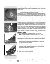
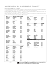
Setting Circles
Setting circles included with the LX200R models permit the location of faint celestial
objects not easily found by direct visual observation. The R.A. circle (11, Fig. 1 and
Fig. 40) is located on the top surface of the telescope’s drive base. The Declination
circle (Fig. 39) is located at the top of the fork tine. With the telescope pointed at the
North Celestial Pole, the Dec. circle should read 90° (understood to mean +90°).
Objects located below the 0-0 line of the Dec. circle carry minus Declination coordi-
nates. Each division of the Dec. circle represents a 1° increment. The R.A. circle runs
from 0
hr
to (but not including) 24
hr
, and reads in increments of 5
min
.
14
15
16
17
18
19
20
21
22
23
0
1
12
11
10
9
8
7
5
6
4
3
2
13
Earth’s
Rotation
0 Dec.
South
Celestial
Pole
Right Ascension
Star
Celestial
Equator
-90 Dec.
+90 Dec.
North
Celestial
Pole
(Vicinity
of Polaris)
D
e
c
l
i
n
a
t
i
o
n
1
2
Fig. 38: Celestial Sphere.
APPENDIX A: EQUATORIAL
(POLAR) ALIGNMENT
Important Note:
The "Telescope: Mount"
option of the Setup menu is
set to "Alt/Az" as the default
mount by the factory.The
example presented in this
section assumes that you are
performing an alignment pro-
cedure for the first time with
your telescope and therefore,
the "Telescope: Mount" option
does not need to be selected.
If the telescope is equatorially
mounted, you must choose
the "Polar" option from the
AutoStar II "Telescope Mount"
menu.