


– 8 –
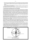
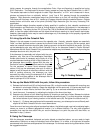
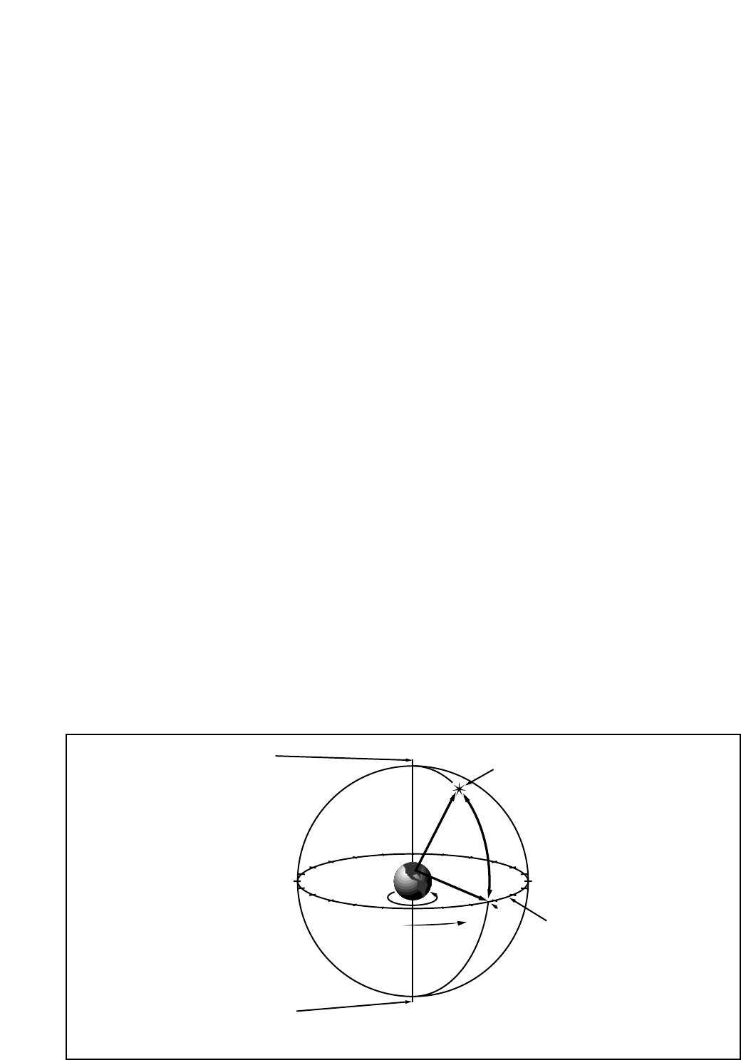
Fig. 2: Celestial Sphere
14
15
16
17
18
19
20
21
22
23
0
1
12
11
10
9
8
7
5
6
4
3
2
13
Earth’s Rotation
0° Dec.
South Celestial Pole
Right Ascension
Star
Celestial Equator
-90° Dec.
+90° Dec.
North Celestial Pole
(Vicinity of Polaris)
D
e
c
l
i
n
a
t
i
o
n
C. Understanding Celestial Movements and Coordinates
Understanding where to locate celestial objects, and how those objects move across the sky is fundamental
to enjoying the hobby of astronomy. Most amateur astronomers adopt the simple practice of “star-hopping”
to locate celestial objects by using star charts or astronomical software which identify bright stars and star
patterns (constellations) that serve as “road maps” and “landmarks” in the sky. These visual reference
points guide amateur astronomers in their search for astronomical objects. And, while star-hopping is the
preferred technique, a discussion of using setting circles for locating objects is desirable since your
telescope is provided with this feature. However, be advised, compared to star-hopping, object location by
use of setting circles requires a greater investment in time and patience to achieve a more precise alignment
of the telescope’s polar axis to the celestial pole. For this reason, in part, star-hopping is popular because
it is the faster, easier way to become initiated in the hobby.
Understanding how astronomical objects move: Due to the Earth’s rotation, celestial bodies appear to
move from East to West in a curved path through the skies. The path they follow is known as their line of
Right Ascension (R.A.). The angle of this path they follow is known as their line of Declination (Dec.). Right
Ascension and Declination is analogous to the Earth-based coordinate system of latitude and longitude.
Understanding celestial coordinates: Celestial objects are mapped according to the R.A. and Dec.
coordinate system on the “celestial sphere” (Fig. 2), the imaginary sphere on which all stars appear to be
placed. The Poles of the celestial coordinate system are defined as those 2 points where the Earth's
rotational axis, if extended to infinity, North and South, intersect the celestial sphere. Thus, the North
Celestial Pole is that point in the sky where an extension of the Earth's axis through the North Pole intersects
the celestial sphere. In fact, this point in the sky is located near the North Star, or Polaris.
On the surface of the Earth, “lines of longitude” are drawn between the North and South Poles. Similarly,
“lines of latitude” are drawn in an East-West direction, parallel to the Earth's equator. The celestial equator
is simply a projection of the Earth's equator onto the celestial sphere. Just as on the surface of the Earth,
imaginary lines have been drawn on the celestial sphere to form a coordinate grid. Celestial object positions
on the Earth's surface are specified by their latitude and longitude.
The celestial equivalent to Earth latitude is called “Declination,” or simply “Dec,” and is measured in degrees,
minutes or seconds north ("+") or south ("-") of the celestial equator. Thus any point on the celestial equator
• With the front of the viewfinder already centered in the front bracket ring, look through the viewfinder
and loosen or tighten, as appropriate, one or more of the rear viewfinder bracket ring thumbscrews (26)
until the viewfinder’s crosshairs are likewise centered on the object previously centered in the main
telescope.
• Check this alignment on a celestial object, such as a bright star or the Moon, and make any refinements
necessary, using the method outlined above.
With this alignment performed, objects first located in the wide-field viewfinder will also be centered in the
main telescope’s field of view. (Note: The viewfinder and telescope present an image which is upside-down.)