


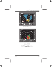

PRIMUS
R
660 Digital Weather Radar System
A28–1146–111
REV 2
Radar Facts
5-28
WEATHER DISPLAY CALIBRATION
Ground based Nexrad radars of the National Weather Service display
rainfall levels in dBZ, a decibel scaling of an arbitrary reflectivity factor
(Z). The formula for determining dBZ is: dBZ = 16 log R + 23, where R
is the rainfall rate in millimeters per hour. The Nexrad radar displays
rainfall in 15 color coded levels of 5 dBZ per step.
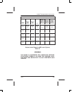
There is a close correspondence in rainfall rates between the colors in
the PRIMUS
R
airborne radars and color families in a Nexrad display. To
help the pilot in comparing them, table 5–6 shows PRIMUS
R
radar
colors, rainfall rates, and dBZ.
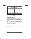
The dBZ rainfall intensity scale replaces the video integrated processor
(VIP) intensity scale used in the previous generation ground based
radars. Table 5–7 compares the classic VIP levels, rainfall rates, and
storm categories with the new dBZ levels. Refer to Section 6 of FAA
Advisory Circular AC–00–24B for additional information on VIP levels.
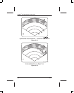
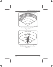
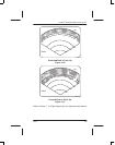
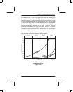
Table 5–6 also shows maximum calibrated range for each color level.
This is the maximum range where the indicated rainfall rate can be
detected if there is no intervening radar signal attenuation caused by
other precipitation. Beyond calibrated range, the precipitation appears
at a lower color level than it actually is. For example, (with a 12–inch
antenna) a red level storm can appear as a green level at 200 miles, as
you fly closer it becomes yellow, and then red at 130 miles. As covered
in the RCT description, intervening rainfall reduces the calibrated range
and the radar can incorrectly depict the true cell intensity.
The radar calibration includes a nominal allowance for radome losses.
Excessive losses in the radome seriously affect radar calibration. One
possible means of verification is signal returns from known ground
targets. It is recommended that you report evidence of weak returns to
ensure that radome performance is maintained at a level that does not
affect radar calibration.
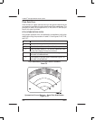
To test for a performance loss, note the distance that the aircraft’s base
city, a mountain, or a shoreline can be painted from a given altitude.
When flying in familiar surroundings, verify that landmarks can still be
painted at the same distances.
Any loss in performance results in the system not painting the reference
target at the normal range.