


PRIMUS
R
660 Digital Weather Radar System
A28–1146–111
REV 2 5-25
Radar Facts
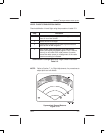
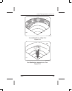
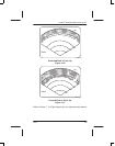
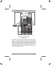
The following are some truths about weather and flying, as shown in
figure 5–29.
D Turbulence results when two air masses at different temperatures
and/or pressures meet.
D This meeting can form a thunderstorm.
D The thunderstorm produces rain.
D The radar displays rain (thus revealing the turbulence).
D In the thunderstorm’s cumulus stage, echoes appear on the display
and grow progressively larger and sharper. The antenna can be
tilted up and down in small increments to maximize the echo pattern.
D In the thunderstorm’s mature stage, radar echoes are sharp and
clear. Hail occurs most frequently early in this stage.
D In the thunderstorm’s dissipating stage, the rain area is largest and
shows best with a slight downward antenna tilt.
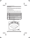
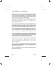
Radar can be used to look inside the precipitation area to spot zones
of present and developing turbulence. Some knowledge of meteorology
is required to identify these areas as being turbulent. The most
important fact is that the areas of maximum turbulence occur where
the most abrupt changes from light or no rain to heavy rain occur. The
term applied to this change in rate is rain gradient. The greater the
change in rainfall rate, the steeper the rain gradient. The steeper the
rain gradient, the greater the accompanying turbulence. More
important, however, is another fact: storm cells are not static or stable,
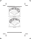
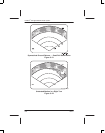
but are in a constant state of change. While a single thunderstorm
seldom lasts more than an hour, a squall line, shown in figure 5–30, can
contain many such storm cells developing and decaying over a much
longer period. A single cell can start as a cumulus cloud only 1 mile in
diameter, rise to 15,000 ft, grow within 10 minutes to 5 miles in
diameter and tower to an altitude of 60,000 feet or more. Therefore,
weather radar should not be used to take flash pictures of weather, but
to keep weather under continuous surveillance.