


– 7 –
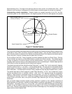
Right Ascension (R.A.). The angle of this path they follow is known as their line of Declination (Dec.). Right
Ascension and Declination is analogous to the Earth-based coordinate system of latitude and longitude.
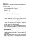
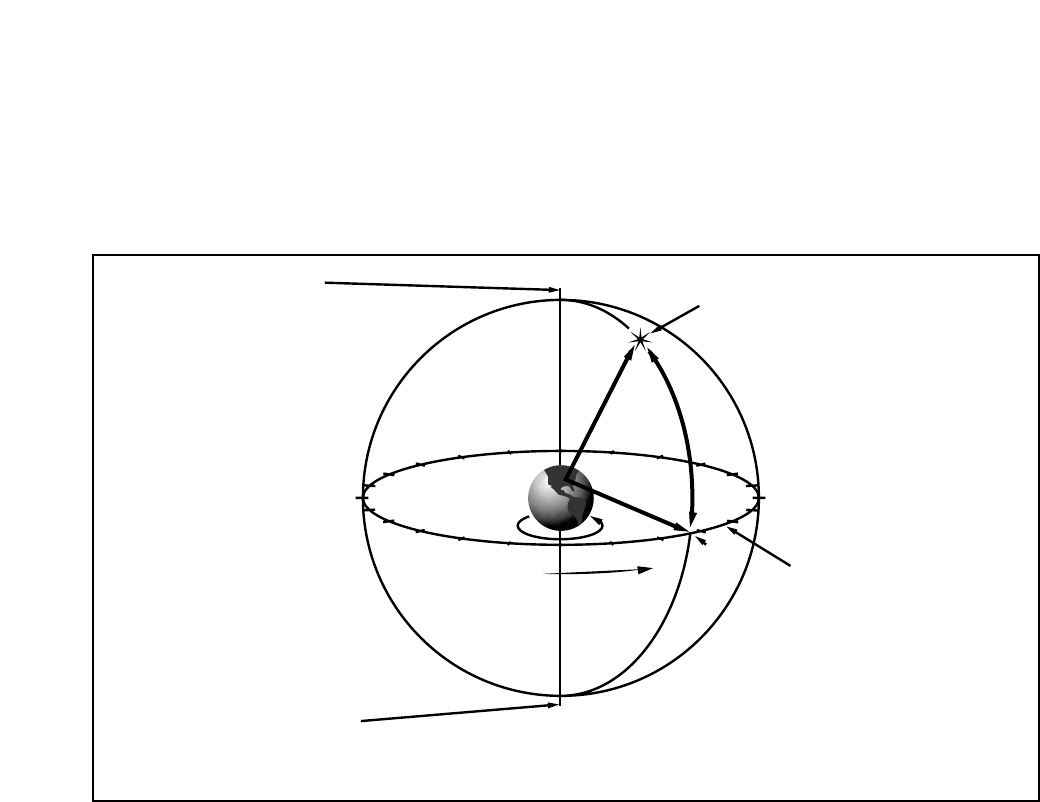
Understanding celestial coordinates: Celestial objects are mapped according to the R.A. and Dec.
coordinate system on the “celestial sphere,” the imaginary sphere on which all stars appear to be placed.
The Poles of the celestial coordinate system are defined as those 2 points where the Earth's rotational axis,
if extended to infinity, North and South, intersect the celestial sphere. Thus, the North Celestial Pole is that
point in the sky where an extension of the Earth's axis through the North Pole intersects the celestial sphere.
In fact, this point in the sky is located near the North Star, or Polaris.
On the surface of the Earth, “lines of longitude” are drawn between the North and South Poles. Similarly,
“lines of latitude” are drawn in an East-West direction, parallel to the Earth's equator. The celestial equator
is simply a projection of the Earth's equator onto the celestial sphere. Just as on the surface of the Earth,
imaginary lines have been drawn on the celestial sphere to form a coordinate grid. Celestial object positions
on the Earth's surface are specified by their latitude and longitude.
The celestial equivalent to Earth latitude is called “Declination,” or simply “Dec,” and is measured in degrees,
minutes or seconds north ("+") or south ("-") of the celestial equator. Thus any point on the celestial equator
(which passes, for example, through the constellations Orion, Virgo and Aquarius) is specified as having
0°0'0" Declination. The Declination of the star Polaris, located very near the North Celestial Pole, is +89.2°.
The celestial equivalent to Earth longitude is called “Right Ascension,” or “R.A.” and is measured in hours,
minutes and seconds from an arbitrarily defined “zero” line of R.A. passing through the constellation
Pegasus. Right Ascension coordinates range from 0hr0min0sec up to (but not including) 24hr0min0sec.
Thus there are 24 primary lines of R.A., located at 15 degree intervals along the celestial equator. Objects
located further and further east of the prime (0h0m0s) Right Ascension grid line carry increasing R.A.
coordinates.
With all celestial objects therefore capable of being specified in position by their celestial coordinates of
Right Ascension and Declination, the task of finding objects (in particular, faint objects) in the telescope can
be simplified. The setting circles, R.A. (16) and Dec. (13) of the Polaris 60EQ-D telescope may be dialed,
in effect, to read the object’s coordinates, positioning the object in the vicinity of the telescope’s telescopic
field of view. However, these setting circles may be used to advantage only if the telescope is first properly
aligned with the North Celestial Pole.
Figure 2: Celestial Sphere
14
15
16
17
18
19
20
21
22
23
0
1
12
11
10
9
8
7
5
6
4
3
2
13
Earth’s Rotation
0° Dec.
South Celestial Pole
Right Ascension
Star
Celestial Equator
-90° Dec.
+90° Dec.
North Celestial Pole
(Vicinity of Polaris)
D
e
c
l
i
n
a
t
i
o
n