


78-8130-6151-8-E 41
Sending iD Data to GPS
(Capture-Transmit Mode / Mode 2)
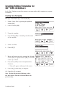
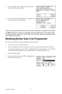
Menu [SK] + Setup [SK] + More>> [SK] + More>> [SK] + Com [SK Toggle] + GIS
Receivers that have marker locating capability (indicated by ‘iD’ in the model number)
can be configured to send 3M
™
EMS iD Marker data directly to some GPS devices.
When a marker is located and read, the information read from the iD marker with feature
and attribute data is sent to the GPS device and is stamped with latitude, longitude and
date/time data. The data acquired during this logging process can be uploaded to GIS
mapping software. For more information and detailed instructions pertaining to specific
GPS units, refer to www.3M.com/dynatel GPS instruction sheet.
Path Mapping with GPS
The M-Series cable and pipe locators are compatible with hand-held GPS devices and
now have the ability to map the path of under ground target facilities. While measuring
the depth to the target, the technician can automatically log the coordinates of the
path on the GPS device. These logged points contain the Trace template that can have
valuable information regarding the facility (owner, utility, size, etc.) and the method used
to find the path (frequency, current, and measured depth).
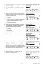
In order to transmit the path information to a GPS device, the GPS has to have the
ability to accept information on one of its com ports at 4800 Baud. Using the manual
supplied with the GPS device, configure the com port of the GPS to communicate with
the receiver.
If ArcPad
™
is the mapping software on the mobile device, download the 3M software
application script from the website: www.3M.com/dynatel
With 3M’s ArcPad
™
application installed, the receiver will send the path information
(locate frequency, depth, current, and trace template information) into the software
program as a logged point and can be saved as a .shp file.
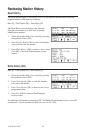
Create Trace Templates
The easiest way to create a Trace template is using the Dynatel PC Tools software.
(Software available for no charge at www.3M.com/dynatel - 3M
™
Dynatel
™
M-Series
Locator PC Tools).
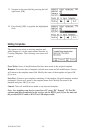
1. Create a TRACE template.
2. Save and download the template to the receiver.
Up to four Trace Templates can be stored on the Receiver.
Each Trace template is limited to 132 user editable characters.
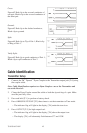
The trace template appears in table format: two columns with six lines.
The first column is limited to 8 characters and the second column is limited to 14
characters. In addition to the 132 character table, the receiver will send a sequence
number, the frequency, the measured depth of the conductor, and the current to the GPS.