


run; enter how long you want, and it will
automatically turn it on. You don’t need
to know the satellite station number or
any of that, because it looks it up for
you.”
“It’s just a great, great benefit,” says
Tom Walker, Golf Course Superintendent
at The Inverness Club in Toledo, Ohio.
“The ability to change the time of cer-
tain sprinklers, to take your mouse and
loop around a few heads and put them
on hold for one day, two days, whatever,
it’s wonderful.”
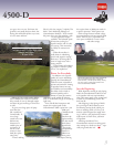
Built in 1903, The Inverness has host-
ed many major tournaments, including
four U.S. Opens. It typically ranks
among the best-groomed courses in
America, so Walker has high standards to
uphold. He feels that SitePro and T.Map
have helped him a lot.
“There’s so much flexibility,” he adds.
“Not only is it an excellent irrigation
package, it also gave me an accurate map
of the golf course. I can use it for chart-
ing square footages, charting out holes,
locating drain lines, even trees,” he says.
“As far as saving me time and getting the
job done better, it’s just wonderful.”
Easy Installation
When T.Map is installed, whether with
new or existing SitePro software, it
requires a designer or consultant to pro-
vide an AutoCAD image of the golf
course—from a survey, GPS program,
aerial photos or even drawn freehand.
GPS isn’t required for T.Map, but it does
improve accuracy.
The AutoCAD data is then converted
into T.Map-shaped files and layered
color-coded images.
“What the data conversion does is to
look at all this
course info, create
what it needs to
create, and saves it
in a zip file,”
explains Toro’s
Jurkis. “That one
file is all you need.
Tell SitePro to do a File Open, and there
it will be.”
When setting up the initial AutoCAD
image, which most new courses already
have, you can determine how detailed
you want it to be.
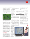
Everything You’re Looking For
“It’s unlimited what you can do,” says
Steve Glossinger, Golf Course Manager
at Caves Valley Golf Club in Baltimore,
Maryland. “We put in all the surfaces,
contour lines, fairways, bunkers, trees,
even paths and buildings. We did just
about everything on the property.”
Caves Valley, site of this year’s Senior
Open, has relied on computerized irriga-
tion control for several years, but T.Map
is a big improvement, Glossinger feels.
“I didn’t
know it was
going to be
this good,
quite
frankly,” he
says. “It’s
friendlier; I
picked up on
it quicker. It
has every-
thing super-
intendents
are looking
for. With this
system, you
really see
your golf
course and
where your
heads are and what you’re running. After
this,” he adds, “you wonder how you
survived with the old system. It’s that
good.”
At Caves Valley, T.Map does much
more than irriga-
tion. “You can see
your whole
course,”
Glossinger says,
“so we use it as a
tool to implement
strategies. For
example, we were getting ready to put up
corporate tents, but instead of going
down there and doing all that measuring,
with a couple clicks on the screen we
knew how many tents would fit.”
The advantages of SitePro and T.Map
are just starting to be discovered—water
conservation, irrigation troubleshooting,
locating trees for removal, determining
square footage of greens and bunkers,
measuring for paving estimates—and the
list goes on. Better yet, it’s easy to get
introduced to the program and quickly
benefit from it.
“You don’t need technical savvy to run
this,” says Walker. “You just point your
mouse at something and click. It’s 100
times simpler than programming a VCR.”
5
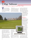
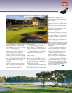
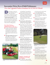
Golf Course Manager of Caves Valley Golf Club Steve Glossinger uses a 40 inch (101.6
cm), flat panel display with his T.Map
TM
system.
“As far as saving me time and
getting the job done better, it’s
just wonderful.”
– Tom Walker
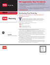
Toro’s T.Map
TM
system provides an accurate
graphical representation of the golf course to
simplify irrigation management.