


– 8 –
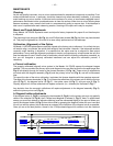
• Check this alignment on a celestial object, such as a bright star or the Moon, and make any
refinements necessary, using the method outlined above.
With this alignment performed, objects first located in the wide-field viewfinder will also be centered in the
main telescope’s field of view. (Note: The viewfinder presents an image which is upside-down.)
UNDERSTANDING CELESTIAL MOVEMENTS AND COORDINATES
Understanding where to locate celestial objects, and how those objects move across the sky is
fundamental to enjoying the hobby of astronomy. Most amateur astronomers adopt the simple practice of
“star-hopping” to locate celestial objects by using star charts or astronomical software which identify bright
stars and star patterns (constellations) that serve as “road maps” and “landmarks” in the sky. These visual
reference points guide amateur astronomers in their search for astronomical objects. And while star-
hopping is the preferred technique, a discussion of using setting circles for locating objects is desirable
since your telescope is provided with this feature. However, be advised, compared to star-hopping, object
location by use of setting circles requires a greater investment in time and patience to achieve a more
precise alignment of the telescope’s polar axis to the celestial pole. For this reason, in part, star-hopping
is popular because it is the faster, easier way to become initiated in the hobby.
Understanding how astronomical objects move: Due to the Earth’s rotation, celestial bodies appear to
move from East to West in a curved path through the skies. The path they follow is known as their line of
Right Ascension (R.A.). The angle of this path they follow is known as their line of Declination (Dec.).
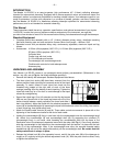
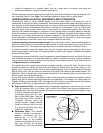
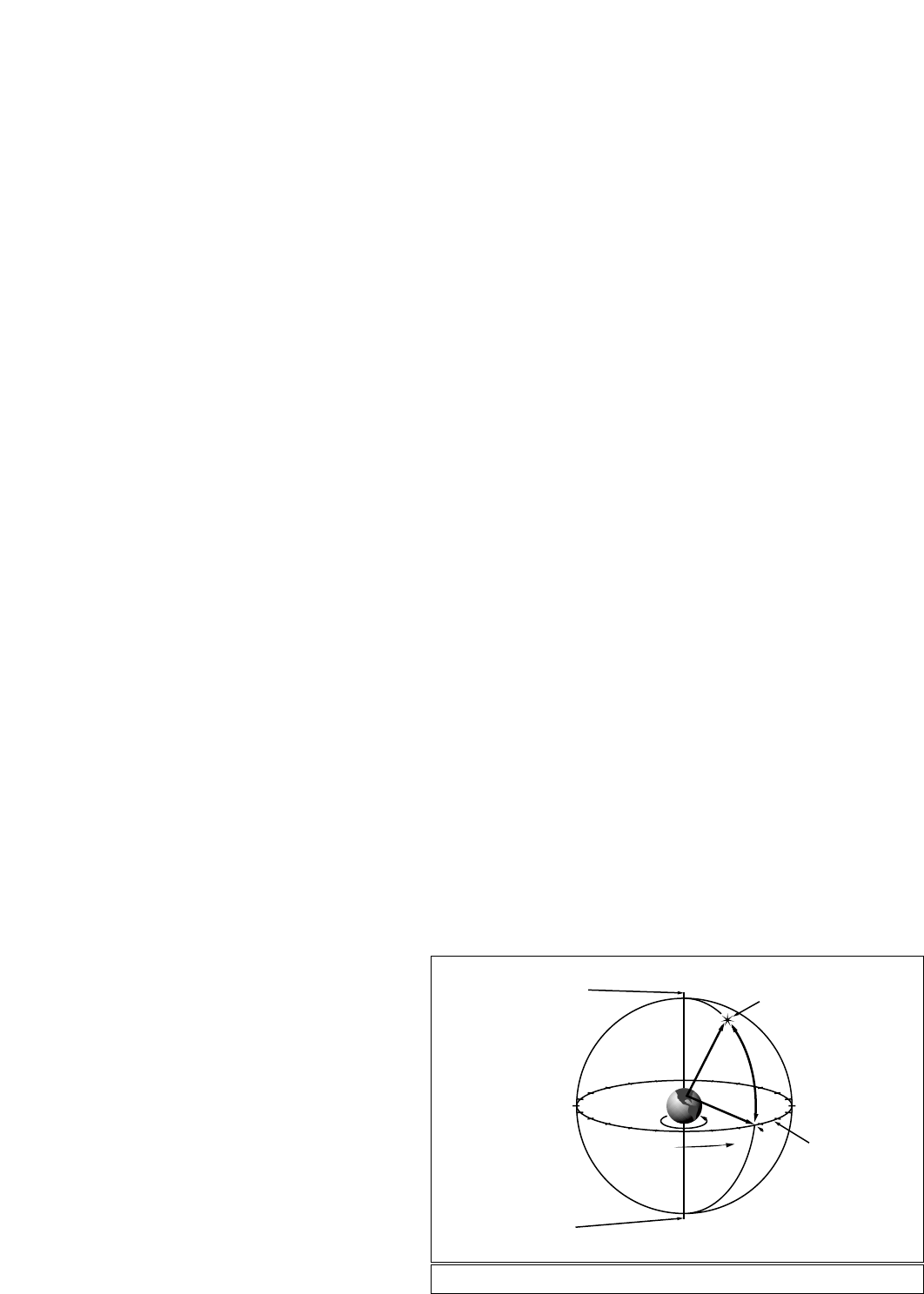
A celestial coordinate system was created that maps an imaginary sphere surrounding the Earth upon
which all stars appear to be placed. This mapping system is similar to the system of latitude and longitude
on Earth surface maps.
In mapping the surface of the Earth, lines of longitude are drawn between the North and South Poles and
lines of latitude are drawn in an East-West direction, parallel to the Earth’s equator. Similarly, imaginary
lines have been drawn to form a latitude and longitude grid for the celestial sphere. These lines are known
as Right Ascension and Declination.
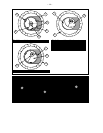
The celestial map also contains two poles and an equator just like a map of the Earth. The poles of this
coordinate system are defined as those two points where the Earth’s North and South poles (i.e., the
Earth's axis), if extended to infinity, would cross the celestial sphere. Thus, the North Celestial Pole (see
Fig. 3) is that point in the sky where an extension of the North Pole intersects the celestial sphere. The
North Star, Polaris, is located very near the North Celestial Pole. The celestial equator is a projection of the
Earth’s equator onto the celestial sphere.
So just as an object's position on the Earth’s surface can be located by its latitude and longitude, celestial
objects may also be located using Right Ascension and Declination. For example: You could locate Los
Angeles, California, by its latitude (+34°) and longitude (118°). Similarly, you could locate the Ring Nebula
(also known as “M57”) by its Right Ascension (18hr) and its Declination (+33°).
■ Right Ascension (R.A.): This celestial version of longitude is measured in units of hours (hr), minutes
(min), and seconds (sec) on a 24-hour "clock" (similar to how Earth's time zones are determined by
longitude lines). The "zero" line was arbitrarily chosen to pass through the constellation Pegasus, a sort
of cosmic Greenwich meridian. R.A.
coordinates range from 0hr 0min
0sec to 23hr 59min 59sec. There are
24 primary lines of R.A., located at
15-degree intervals along the
celestial equator. Objects located
further and further East of the zero
R.A. grid line (0hr 0min 0sec) carry
higher R.A. coordinates.
■ Declination (Dec.): This celestial
version of latitude is measured in
degrees, arc-minutes, and arc-
seconds (e.g., 15° 27' 33"). Dec.
locations North of the celestial
equator are indicated with a plus (+)
sign (e.g., the Dec. of the North
celestial pole is +90°). Dec. locations
14
15
16
17
18
19
20
21
22
23
0
1
12
11
10
9
8
7
5
6
4
3
2
13
Rotation de la Terre
0° Déc.
Pôle céleste Sud.
Ascension droite
Etoile
Equateur céleste
Déc.-90° Déc.
+90° Déc.
Pôle nord céleste
D
é
c
l
i
n
a
i
s
o
n
Fig. 2: Celestial Sphere.
North Celestial Pole
(Vicinity of Polaris)
+90° Dec.
Star
Celestial
Equator
-90° Dec.
South
Celestial
Pole